As Sudan’s civil war grinds into its third year, a new satellite-based analysis is offering one of the clearest accounts yet of how Khartoum has been destroyed by conflict, even as media reporting remains severely limit4ed.
The study, by geospatial researcher Jiashu Hu and posted on LinkedIn, does an impressive job reconstructing the impact of fighting in the capital using multiple streams of open-source satellite data. His findings point to a city that has undergone, and continues to undergom sustained collapse: a 68% reduction in nighttime economic activity, structural damage affecting 7.8% of the urban area, and thousands of fatalities concentrated in the same densely populated districts.
Action on Armed Violence relies on media incident-based reporting to track civilian harm in Sudan, and Hu’s analysis provides a parallel evidentiary record. As we have long said, Sudan has become one of the most difficult environments in the world for journalists to operate, with communication blackouts and insecurity limiting the flow of news.
As we have seen in other conflicts and in similar conditions, satellite data is increasingly being used to reconstruct events that cannot be directly observed.
AOAV’s own data shows a sharp escalation in civilian casualties from explosive violence in Sudan since April 2023. Civilian harm from such weapons reached at least 5,440 recorded deaths and injuries in 2025, with around 25 civilians harmed per incident of explosive violence. Almost all of these casualties occurred in populated areas such as residential districts, markets and camps and we likely only scratched the surfce.
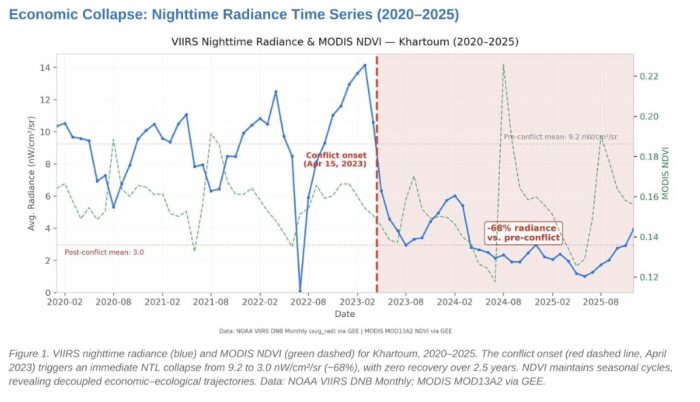
Hu’s satellite analysis begins with a temporal signal: the collapse of nighttime light emissions across Khartoum. As shown in his Figure 1, radiance levels fall sharply at the onset of conflict in April 2023 and remain depressed through 2025, with no meaningful recovery. The decline, from an average of 9.2 to 3.0 nanowatts per square centimetre per steradian, indicates a profound contraction in economic activity and population presence.
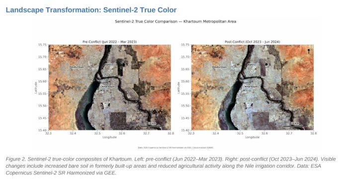
Hu then went onto a direct visual comparison. His Figure 2 presents true-colour satellite imagery of Khartoum before and after the outbreak of conflict. The post-conflict image shows an increase in bare soil within previously built-up areas, alongside a visible reduction in agricultural activity along the Nile corridor. These changes would be, in theory at least, consistent with displacement, infrastructure damage and the breakdown of irrigation systems.
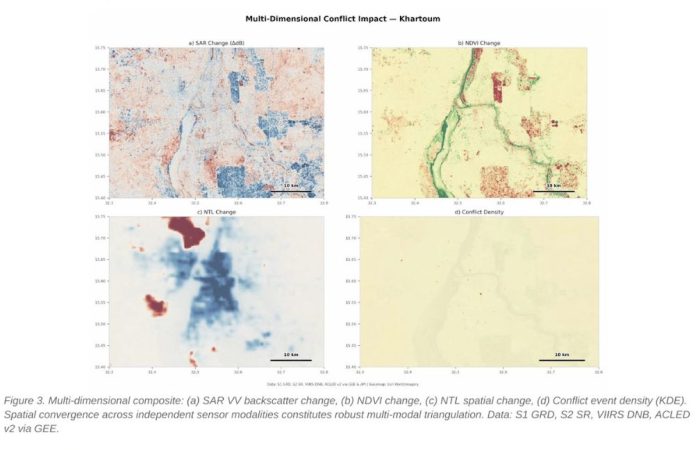
A third layer of Hu’s analysis shows him examining independent satellite indicators that converge on the same areas Figure 3 brings together radar-derived structural change (SAR), vegetation dynamics, nighttime light variation and recorded conflict event density. Although derived from different sensors, these four datasets point to overlapping hotspots in central Khartoum, Omdurman and Bahri.
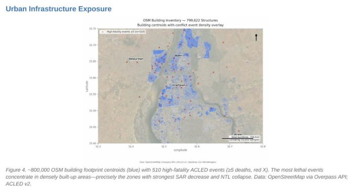
Finally, Hu looks at where the harm took place. In Figure 4, he overlaid conflict event data with nearly 800,000 mapped building locations. High-fatality incidents are shown to cluster overwhelmingly within dense urban areas, particularly in central districts. These are precisely the zones where the strongest declines in both structural integrity and nighttime light emissions are observed. It seems that the most lethal violence is occurring in the most densely populated parts of the city.
This, it goes without saying, is what we have seen in the media reporting of violence in Sudan.
AOAV has consistently documented that explosive weapons used in populated areas produce disproportionately high civilian casualties. In 2025, 96% of those killed or injured by explosive weapons in such areas in Sudan were reportedly civilians. The clustering of fatalities in residential districts and markets in Khartoum reflects this.
There are limits to what Hu’s analysis can show. Satellite proxies cannot distinguish definitively between causes such as displacement, power outages or direct destruction. Nor can they identify individual casualties. Yet his research is rich in that it offers insight into a context where ground reporting is fragmentary and often censored, Hu tracking change across multiple dimensions provides a powerful tool for verification.
For Sudan, where the scale of civilian harm is widely believed to be undercounted, such methods are increasingly central. The war has not only inflicted widespread damage, but also obscured its own effects. From orbit, however, the pattern is seen. Khartoum appears to be being pummelled, with the heaviest toll borne seen in those very places where civilians are most concentrated.
Did you find this story interesting? Please support AOAV's work and donate.
Donate